Podcast - historical solar eclipse maps
Hello, my name is Michael Zeiler and I’m going to talk to you about historical maps of solar eclipses.
I work in the geographic information systems (GIS) industry and I write books and documentation on geographic data modeling. A personal interest of mine is traveling to witness the greatest spectacle on earth; a total eclipse of the sun. I enjoy combining my professional skills with my eclipse interest to create new maps of solar eclipses.
In today’s podcast, I will illustrate the rich heritage of eclipse maps through 12 examples selected from a collection of over 1300 historical eclipse maps on my web site, eclipse-maps.com. These maps that I’m about to discuss are displayed on a special page on my web site. At this time, I’d like to encourage you to pause this podcast and go to eclipse-maps.com. On the front page, you’ll see a yellow box announcing the special page to accompany this podcast. Please click on that yellow box and you’ll be taken to a page with 12 eclipse maps and the transcript for this podcast. You can click on each map to view a full resolution image. When you are ready, please resume this podcast.

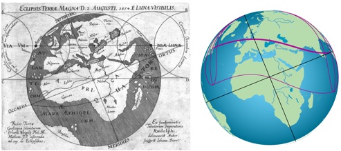
We begin with the earliest known eclipse map. In the year 1654, Erhard Weigel was a professor of mathematics and astronomy at the University of Jena in Germany. The time was ripe for the first eclipse map as Johannes Kepler had recently published his laws of planetary motion and this breakthrough allowed for accurate eclipse predictions. This map was forgotten until rediscovered in 2009 by the German historian Klaus Dieter-Herbst, who shared this eclipse map with me.
This page accompanies a podcast on 365 Days of Astronomy (365daysofastronomy.org) from September 25, 2011. Below is the transcript and maps discussed in this podcast. Click on any map to view each map in high resolution.
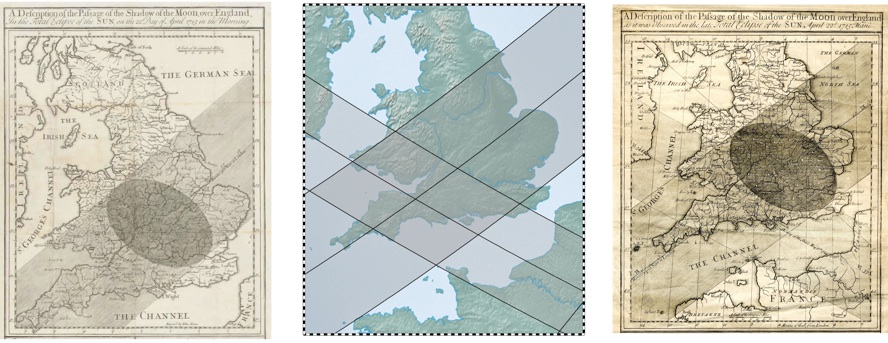
Certainly, the most famous early eclipse maps are those published by Edmund Halley, most famous for the comet that bears his name. Halley published a set of four maps that were widely distributed throughout Britain. Halley published his first eclipse map (on the left) before the total solar eclipse of 1715 that passed over London. His maps had a positional accuracy of about 30 kilometers, a remarkable achievement of the day. Halley solicited field reports of eclipse observers and made a new map with a corrected path for the 1715 eclipse as well as a prediction of the 1724 eclipse.
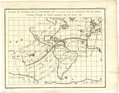
For the eclipse of April 23, 1781, Mademoiselle de St Laurent of France drafted this interesting eclipse map, one of the favorites in my collection. It is fascinating because it combines an accurate rendering of an eclipse identical to the form of modern eclipse maps against a cartographic background of uncertain and unknown continental boundaries. This map eloquently speaks to the fact that the state of astronomical calculations in the 18th century was considerably more advanced than the geographic knowledge of the world.
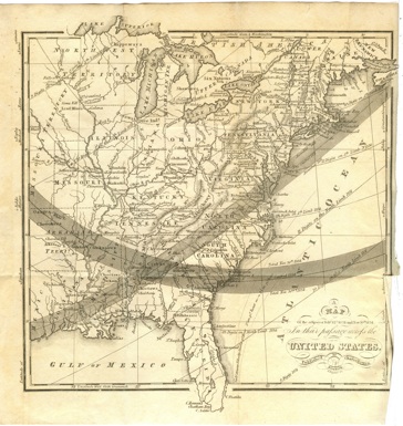
Solar eclipses crossed over the eastern United States in 1831 and 1834. This map from the 1834 edition of the American Almanac and Repository of Useful Knowledge is the second earliest known eclipse map from the United States. The first American eclipse map is from the same almanac for the year 1831. This eclipse map is simultaneously one of the most detailed maps of the eastern United States from this time as well as a record of two eclipses that were widely observed in this young country.
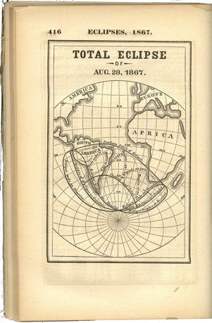
By the 19th century, eclipse maps were common in national almanacs such as the American Ephemeris and Nautical Almanac, the French almanac Connaissance des Temps, and the British Nautical Almanac and Astronomical Ephemeris. This 1867 map from the American Ephemeris is typical of this era and the publication of eclipse maps in all major national almanacs continues to this day.
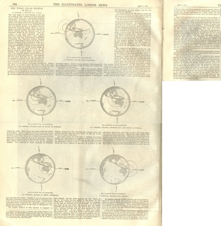
One of my favorite 19th century illustrators of astronomy is Richard Anthony Proctor. He wrote many books for the public on the wonders of the sky and he had a unique skill in popularizing astronomy. I like to think of Proctor as the Carl Sagan of his day.
For the December 9, 1871 issue of the Illustrated London News, Proctor contributed an article with a preview of the total solar eclipse of December 12. This article contained five illustrations with simple and clear diagrams of the eclipse as seen from the perspective of the sun. Take a closer look at these figures as they depict how earth’s rotation, tilt of the earth’s axis, and path of the moon’s shadow combine to create the curved path of an eclipse.
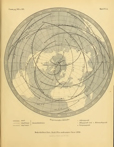
Among eclipse experts, the 1887 Canon der Finsternisse (or, Canon of Eclipses) by Theodor von Oppolzer, stands alone in the pre-computer era as the epic compendium of eclipse calculations and maps spanning over three millennia.
Oppolzer recruited a team of 10 human calculators to calculate paths of 8000 eclipses. Because of the magnitude of this task, only the begin, middle, and end points of each eclipse was calculated and curves were drawn through those points. So deviations are noticeable when Oppolzer’s maps are compared to modern eclipse maps, but his achievement is still monumental and stimulated historical research of eclipses in antiquity as well as identifying patterns in eclipse cycles.
Sadly, Oppolzer did not live to see the publication of his opus. He inspected the final proof-sheets of the Canon in the hours before his death at the age of 45.
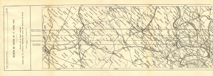
The path of the eclipse of April 17, 1912 was so narrow that calculating the precise centerline was crucial. This map from the French journal L’Astronomie presented five centerlines plotted by five almanac authorities. Those who successfully picked a spot on the true centerline witnessed a total solar eclipse that lasted but an instant.
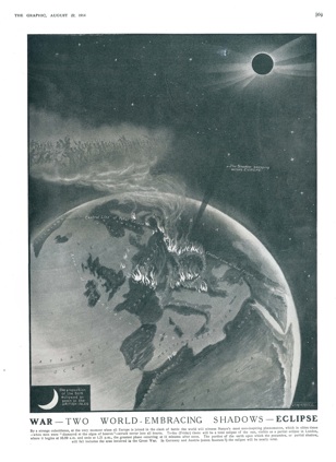
You may have heard the story about the famous total solar eclipse of 585 B.C. that stopped a war in Greece between two warring cities. Sadly, the eclipse of August 21, 1914 did not have that effect. This haunting map shows Europe in flames after the outbreak of World War I with the eclipse path slicing through the battlefield.
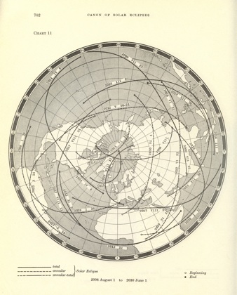
In 1966, the Canon of Solar Eclipses was published by Jean Meeus, Carl Grosjean, and Willy Vanderleen. This was the first extended set of eclipse calculations done with an electronic computer and at last superceded Oppolzer’s 1887 Canon of Solar Eclipses. The maps in the 1966 Canon are similar in form to the 1887 Canon, but far more accurate.
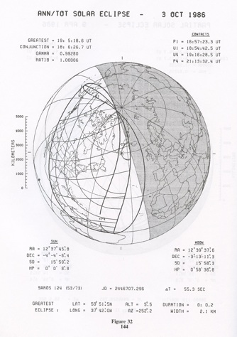
In 1987, Fred Espenak of the NASA Goddard Space Flight Center, published his Fifty Year Canon of Solar Eclipses containing individual maps for each solar eclipse. Espenak’s Canon was widely published and eclipse chasers today still use this book as a standard reference for planning eclipse expeditions.
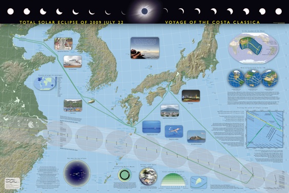
Now for the last map of this podcast. I’m doing my best to advance the development of eclipse mapping. I published this map for the eclipse of July 22, 2009 for the voyage of the Costa Classica. On this map, you’ll find details about the ship’s successful quest to reach the point of greatest eclipse for the longest eclipse of this century. This map tells a comprehensive story of the eclipse shared by a thousand eclipse chasers on board this memorable cruise.
Thank you for listening to this podcast and I hope you share my appreciation for the precision, majesty, and artistry of eclipse maps.
End of podcast. To see the full collection of historical eclipse maps on this web site, click on History on the top of this page. To see the new eclipse maps I publish, click on Gallery.
