Solar eclipse maps from 1931 to 1940

Sources
The maps from the American Ephemeris and Nautical Almanac and eclipse supplements from 1931 to 1940 are either scanned from the collection of Michael Zeiler or scanned from holdings at the Federal Depository Library in Albuquerque, N.M. The maps from the French almanac Connaissance des Temps are from the collection of Michael Zeiler.
All of the eclipse maps by William Rigge published in Popular Astronomy can be found by searches on http://www.adsabs.harvard.edu/. The maps by Charles Smiley, Seagrave, and the Royal Astronomical Society of Canada can also be found by searches on this web site.
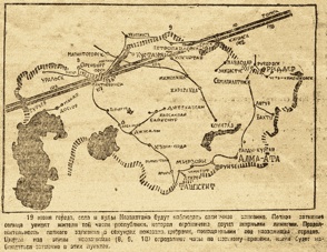
Map of 1936 June 19 eclipse over Kazakstan from Pravda is from http://www.oldgazette.ru/kpravda/18061936/01-2.html
Image of eclipse viewer and map of 1932 August 31 eclipse by Harvey & Lewis is from http://www.plaistowhistorical.org/exhibits/1932eclipse/NEpath.jpg
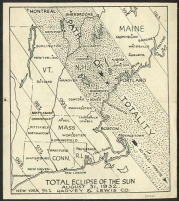
Photo of Soviet eclipse observors of 1936 is from http://allan999.livejournal.com/5733731.html.

The New England region of the United States was favorably situated for a series of eclipses in the 20th century: total solar eclipses in 1925, 1932, 1959, and 1963 and near misses in 1970 and 1972. New England also enjoyed an annular solar eclipse in 1994.
You can read a remembrance of the 1932 eclipse over New England at http://www.plaistowhistorical.org/exhibits/1932eclipse/NEpath.jpg
The total solar eclipse of 1936 June 19 began in the Mediterranean and traversed the full width of the Soviet Union before ending at sunset over Japan. This eclipse map shows the track of the eclipse of Kazakhstan and was published in Pravda.
