Solar eclipse maps from 1901 to 1910
Sources
The maps from the British Nautical Almanac and Astronomical Ephemeris were found and extracted from http://books.google.com. The maps from the French almanac Connaissance des Temps are from the collection of Michael Zeiler or were found and extracted from http://books.google.com. The maps from the American Ephemeris and Nautical Almanac from 1901 to 1910 are scanned from the collection of Michael Zeiler
The newspaper pages with eclipse maps and stories were found at U.S. Library of Congress page on Chronicling America: Historican American Newspapers, http://chroniclingamerica.loc.gov/
Sheridan Williams provided several eclipse maps for the 1901 and 1905 eclipses. I believe these maps are from eclipse supplements to the British Nautical Almanac, but this needs to be confirmed.
The 1901 map by A.C.D. Crommelin of the 29-Year Eclipse Cycle is from http://adsabs.harvard.edu/full/1901Obs....24..379C
The map of the 1905 August 30 TSE, Hamburgische Sonnenfinsternis-Expedition is from http://adsabs.harvard.edu/full/1907MiHam...4A...1S
All of the eclipse maps by William Rigge published in Popular Astronomy can be found by searches on http://www.adsabs.harvard.edu/
The 1910 map by Paul Schwahn is found at http://www.archive.org/stream/mathematischeth00schwgoog
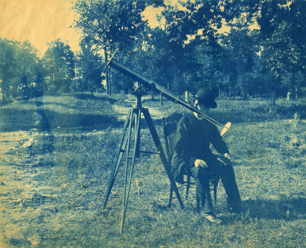
Beginning this decade, you will find many fine eclipse maps by Fr. William F. Rigge, who wrote many articles for Popular Astronomy, a now defunct magazine for amateur astronomers that was published by Carleton College from 1983 to 1951. About 35 of Rigge’s eclipse maps are found on this and the two succeeding galleries of historical eclipse maps. Father Rigge was a professor of astronomy and physics at Creighton College in Omaha, Nebraska.
Rigge performed his own ecilpse calculations and his maps are detailed records of many aspects of eclipses. Unlike many simpler eclipse maps of this era, Rigge mapped many eclipse features such as isochrons for the beginning and ending of eclipse and time of greatest eclipse, isomagnitudes for eclipse, and limit lines for the eclipse. An interesting eclipse feature that Rigge mapped are curves for tenths of eclipse magnitude at sunrise and sunset; I have not seen these curves drawn on any eclipse maps besides Rigge’s.
Despite the advanced characteristics and fine cartographic qualities of Rigge’s maps, they retain a curiously parochial quality: Rigge’s maps consistently span only the 48 coterminus United States. Even his map for the 1905 eclipse, with it’s path beginning near the U.S.-Canada international border, does not stray outside the national border.
William Rigge at the telescope awaiting the total solar eclipse of 1900.
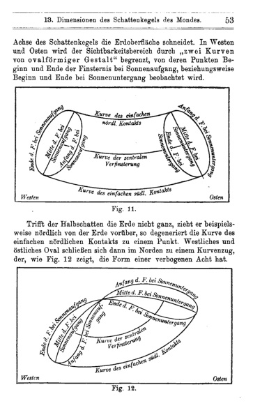
This page is from Paul Schwahn’s 1910 Mathematische Theorie der Astronomischen Finsternisse, a well-illustrated treatise on eclipse theory. From http://www.archive.org/stream/mathematischeth00schwgoog
