Solar eclipse maps from 1851 to 1860
American Ephemeris and Nautical Almanac
While the British Nautical Almanac and Astronomical Ephemeris was widely used by many sea-faring nations, it became desirable for the United States to inaugurate its own national almanac so that astronomical tables could reference the Washington meridian, to replace expenditures to England with a local almanac, and for reasons of national pride. In 1849, the U.S. Congress passed legislation for the creation of an American almanac.
The first edition of the American Ephemeris and Nautical Almanac appeared for the year 1855. This almanac contains astronomical data published for both the Washington and Greenwich meridians and included maps of solar eclipses from its first edition onwards.
The rationale for two meridians is explained in the following extract from the American Ephemeris and Nautical Almanac:
Title page from the first American Ephemeris and Nautical Almanac.
The Spanish eclipse of 1860
An important total solar eclipse was that of July 18, 1860 which traversed Spain. This eclipse is noteworthy because the British astronomer, Warren De La Rue, captured the earliest photographs of the solar corona which were a sensation in that time. By this time, the notion of traveling to another country for the specific purpose of observing an eclipse began to be established.
Two fine maps were made in Spain for this eclipse. Francisco Coello was the author of the Atlas de España and made an interesting map with increased cartographic detail within the path of totality. Another map by an unknown cartographer produced an eclipse map with a densification of place names within the path of totality. Increasing cartographic detail within the path of totality is appropriate to draw the map reader’s attention to this area of interest.
This detail from Coello’s 1860 eclipse map for Spain demonstrates a cartographic technique of increasing topographic detail and place names within the path of totality.
From a cartographic perspective, this is one of the finest eclipse maps produced up to this date.
Sources
The maps from the British Nautical Almanac and Astronomical Ephemeris,the American Ephemeris and Nautical Almanac
are scanned from the library of U.C. Berkeley. The maps from Harper’s New Monthly Magazine were found and extracted from http://books.google.com.
The eclipse map of 1858 from the French magazine L’Illustration is from Wikimedia Commons, http://commons.wikimedia.org/
The Spanish maps of the 1860 eclipse are from the Biblioteca Digital Hispanica, http://bdh.bne.es
1851 map by August Ludwig Busch from Über die totale Sonnenfinsterniss am 28. Juli 1851 found at http://www.e-rara.ch/astro-eth/
1858 maps by Adolph Drechsler in his book Die Sonnen- und Mondfinsternisse in ihrem Verlaufe can be found at books.google.com
Maps of ancient eclipses of Agothocles and Thales by George Biddell Airy, Astronomer Royal, is from the Philosophical Transactions of the Royal Society, found at http://royalsocietypublishing.org/
Cover of the July 14, 1860 Harper’s Weekly, a U.S. periodical, showing the path of the 1860 total solar eclipse.
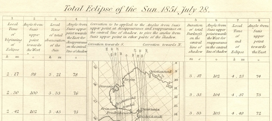
This eclipse map is unique among all the maps on this web site. The interesting feature on this map that is to be found in no other map are local corrections to angle of contact during the eclipse. From the map: “Correction to be applied to the Angles from Sun’s upper point at disappearance and reappearance on the central line of shadow, to give the angles from Sun’s upper point in other parts of the shadow.” Another interesting aspect of this map is that only a narrow strip of land is shown directly on or near the path of totality with the map tilted to follow the general path of eclipse.
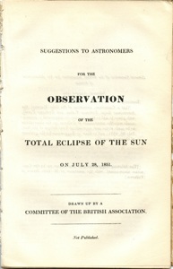
The above map is contained within this pamphlet issued by the British Association
