The total solar eclipse of 1706


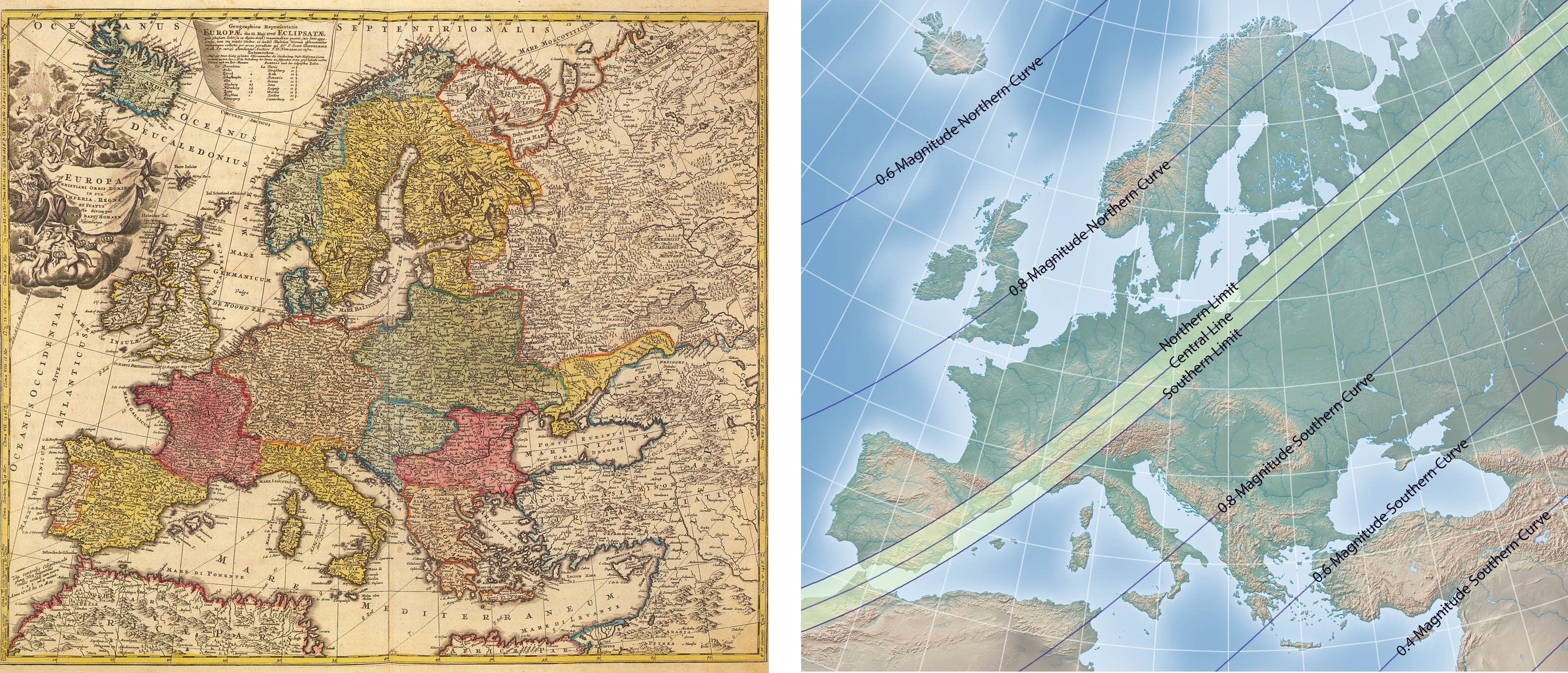
The total solar eclipse of 1706 May 12 cut a diagonal path across Europe from Morocco to Siberia and was widely observed by the public and astronomers of the day such as Cassini and Flamsteed. This eclipse was the subject of at least four eclipse maps of different styles and precision.


Symon van de Moolen of Amsterdam was a mathematician with an interest in solar and lunar eclipse  calculations. In 1705, he published a 16-page book on the 1706 eclipse which contains the eclipse map below. Andreas van Lugtenberg, a teacher of navigation at Rotterdam, published another eclipse map roughly showing the eclipse with two straight lines against a background of the world. This map shows North America with a curious appendage in the northwest.


In 1707, the cartographer Johann Homann and astronomer Johann Doppelmayr began collaborating on a series of eclipse maps, the first of which appears to the upper-right. Homann and Doppelmayr’s map was copied by Peter Schenk Sr., a common practice of the day.

This eclipse map of the 1706 eclipse by Homann and Doppelmayr is remarkably detailed and accurate. This is perhaps the first eclipse map to show the umbral path with southern and northern limit lines, marked as “12 zoll”, equivalent to the 12 “digits” (or “doigts”) seen on other early eclipse maps. A good way to judge the accuracy of this map is to inspect the Gibraltar region. The other eclipse curves are marked “11 zoll”, “10 zoll”, “9 zoll”, and so on for the fraction of maximum eclipse outside the zone of totality. The detail in the upper left of the map lists totality duration and maximum eclipse for a number of European cities.

Solar eclipse maps from 1701 to 1740

Sources


Robert van Gent describes many of the early eclipse maps in this map in a chapter of the book Entwicklung der Sonnenforschung, 2005, “Mapping the lunar shadow - the earliest solar eclipse maps.” van Gent has done extensive research on the maps of Homann and Doppelmayr and much information can be found at http://www.phys.uu.nl/~vgent/


The essential reference for the history of British solar eclipse maps of the 18th century is The Shadow of the Moon, 1997, by Geoff Armitage, curator at the British Library. Armitage also discusses these maps at http://www.fathom.com/feature/122028/index.html. Armitage curated an exhibit of eclipse maps which is reviewed at http://www.mapforum.com/07/7issue.htm


An account of 18th century eclipses is given in Historical Eclipses in Europe by Suzanne Débarbat, 1999 and can be found at http://adsabs.harvard.edu/full/1999CoSka..28..163D


Eclipse maps of this era can be found at the Bibliothèque nationale de France, http://www.bnf.fr


Owen Gingerich wrote an article “Eighteen-Century Eclipse Paths” in Sky & Telescope magazine, 1981, volume 62, page 324-327. This article discusses how Halley used observations after the eclipse to produce a revised and more accurate second edition several months later.


Prof. Jay Pasachoff gives a detailed account of Halley’s maps in the Journal of Astronomical History and Heritage, 2:39:54, 1999, “Halley as an eclipse pioneer: his maps and observations of the total solar eclipses of 1715 and 1724.”


Halley’s post-eclipse report to the Royal Society gave his observations and summarized the reports by others. It’s a fascinating read and can be found at http://rstl.royalsocietypublishing.org/content/29/338-350/245.full.pdf

The eclipse broadsides of Halley


The pivotal eclipse broadsides of Edmund Halley for the eclipses of 1715 and 1724 are probably the most famous early eclipse maps because they were widely available to the English public and prepared many people to successfully observe the eclipse of 1715.


In this period in Britain, a broadside was a sheet printed and sold on the streets on a subject of topical or scientific interest. Although many broadsides of Halley’s map were printed, few survive today and command high prices at auction.

The map on the right is the first eclipse broadside published by Halley before the eclipse of 1715. On the right is a second broadside by Halley a few months after the eclipse. In the middle is a modern map using contemporary eclipse calculations. If you compare the two Halley maps with the modern map, you’ll see the the revised 1715 is very close to the modern calculations. On the second map, Halley also added the path of the 1724 eclipse, due 9 years later.

Halley’s map had a profound influence on British society and his broadsides were followed in later year by many eclipse maps, such as this map of the 1737 eclipse by John Haynes.

Besides the new level of accuracy in eclipse predictions, there are two interesting innovations in Halley’s 1715 eclipse map.


The first innovation is the umbral oval within the map that gives the map reader a picture of the umbra as a shadow intersecting the earth at a moment in time. From this oval, the map reader understands that the shadow is sweeping along the path of totality. The oval is an interesting map feature that combines the geographic context with the temporal dimension of the eclipse and gives the map a sense of dynamism.


The other innovation is Halley’s invitation for eclipse observations, shown in the detail above. Halley did receive reports from many parts of southern England which he applied to create a revised map with improved eclipse lines. This is akin to today’s social networking technology and makes this map participatory instead of a one-way broadcast of information.